In Activities 4 & 5, you will research how one event affected oceanographic conditions at two Gulf of Maine sites.
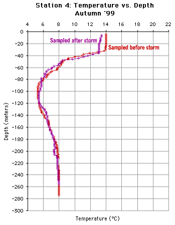
#4) Calculate the thermocline strength before and after an Autumn storm event.
Downland & print “Data Tracking Sheet” (PDF format). For these stations, write down the average water temperature:
-
ABOVE the main thermocline; and
- The first 20 meters BELOW the main thermocline:
| Station 4 | and | Station 8 |
NOTE: You’ll have sets of numbers for BEFORE the storm (red line on graph) and AFTER the storm (purple line on graph).

-
Note these depths under “Temp. ABOVE Thermocline” and “Temp. BELOW Thermocline.”
- Based on these calculations, classify each thermocline as follows:
- Temperature difference is less or equal to than 4 degreesCelsius: WEAK
- Temperature difference is greater than 4 degrees Celsius: STRONG
- In the shown example above, the strength of the thermocline is STRONG (14°C – 8°C = 6°C).
#5) Discover whether a storm event can change ocean layering.
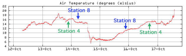
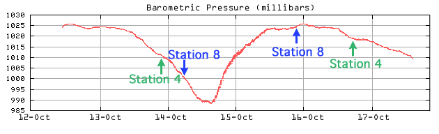
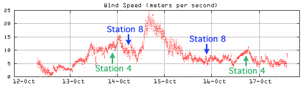
Step A: Link to plots of Air Temperature, Barometric Pressure and Wind Speedduring our Autumn cruise. The dates when we were collected data at Stations 4 and 8 are shown.
- Use these data plots to discuss the storm event itself:
- How windy was it? (Note that 25 meters per second is about 50 miles per hour).
- What was the barometric pressure like during the storm?
- What happened to the AIR temperature during the storm?
Step B: Look at the following data for Stations 4 and 8 during Autumn:
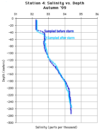
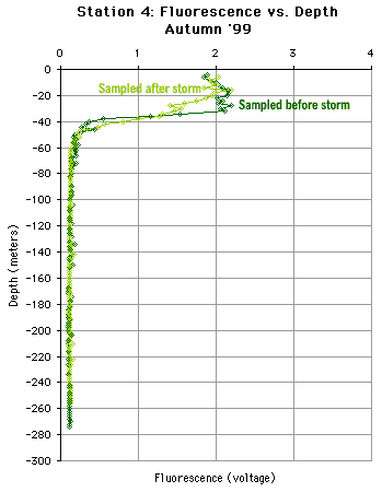
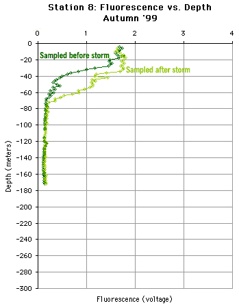
- At Station 4, did the salinity profile change after the storm? What about the fluorescence profiles?
- At Station 8, did the salinity profile change after the storm? What about the fluorescence profiles?
- Did one station experience significantly more change the the other? Can you guess why or why not?
- In general, which factor (i.e., temperature, salinity or fluorescence) was most affected by the storm? Why do you think this is so?
(source)